Monday, May 31, 2010

Poland’s flying universities


The Poles have had a particularly hard time of it the past couple of centuries. They have suffered much at the hands of foreigners. But in reading about their brave underground efforts to educate themselves and resist the efforts of their occupiers to rob them of their identity, I’ve come to admire them for their fighting spirit.

The flying universities were underground educational programmes begun by Polish scholars in the late 1800s to create greater educational opportunities and to resist the suppression of their culture. Meetings were small and were held in private homes and apartments. They were called “flying” universities because the meetings had to constantly be moved from one location to another in order to avoid detection by the authorities. The Polish term can also be translated as “floating universities”.


In the second half of the C18th the Polish-Lithuanian Commonwealth was partitioned among its more powerful neighbours. The bulk of the territory – the eastern half – was taken over by the Russians. The Prussians controlled the portion to the northwest and the Austro-Hungarians took control of the southwest portion. It became increasingly difficult for Poles to receive a higher education. Educational institutions were germanised or russified according to the area; the language and culture of the Poles was suppressed, as were studies in Roman Catholicism.

The first flying university was begun in Warsaw in 1882/3 by women. The 1870s had seen an increase in the educational opportunities available to women. But women were still not allowed to enter into universities in the Prussian and Russian parts of Poland and so they began to organise their own courses. One of the most famous students of the flying university was Marie Sklodowska, who later became Marie Curie (to the right). Curie was the first person to receive two Nobel Prizes, which she was awarded for her work in physics and chemistry.

Men only joined the flying university from 1890. In 1890, the number of registered students was 1,000. Programmes involved humanities, natural and social sciences, mathematics and pedagogy. There were many highly renowned academics serving as lecturers and the standard of education was very high.

The flying university was, of course, an illegal venture. Not many primary sources therefore exist as most documents were destroyed or not even created in order to avoid detection by the authorities. Students’ fees did, however, make it possible to establish a secret library.

The university lasted until 1905. In 1905 greater liberty was afforded to Poland and the flying university became an official association of academic courses. In 1920 it became the Free Polish University.

Under Nazi occupation, however, which began in 1939, Poland’s universities were closed and Poles were kept from receiving any form of higher education. The Germans wanted the Polish people to be a subordinate, servant race, trained only in manual, certain technical and menial occupations. Polish efforts to provide higher education opportunities were once again forced underground.

Underground high schools were established, and these schools provided students for the underground universities. Underground publishing houses were set up to provide teaching materials and textbooks. The subjects taught by the flying universities were extensive, including law, the humanities, economics, biology, mathematics and medicine. Pope John Paul II was trained at an underground seminary.

Well over 100,000 people received some form of underground secondary or tertiary education during the war, and vastly more than that received a primary level education. Nowhere else in Europe did underground teaching educate as many people as it did in Poland.

Ninety percent of the underground activities were located in Warsaw, but teaching, learning and research also took place in other major cities. Little happened in Kraków as most of the professors there had been sent to concentration camps. In fact, everyone involved in underground education was risking deportation or death. Between 1939 and 1940 approximately 9,000 teachers and over 600 professors were murdered by the Nazis.

At the controversial Yalta Conference held by the Allied victors in the Crimea at the end of the war, it was agreed that the Soviet Union should be given control of Poland. It soon became clear, however, that Stalin was not going to allow free elections to take place in Poland, as he had promised. Poland became a satellite state of the Soviet Union; a communist regime was officially established there in 1949.


Churchill, Roosevelt & Stalin, February 1945.

The Communists ruled through a reign of terror, and little underground academic acitvity could take place. Official Polish universities were allowed to operate under the Communists, but the state-sanctioned syllabi were used as vehicles for communist propaganda. Members of the Communist Party were made directors of education so as to ensure that the various curricula were in keeping with the interests of the Soviet government.

Stalin died in 1953. By 1956 the political situation in Poland had eased up just enough to allow flying universities to begin operating again. Much focus was given to history and philosophy, subjects that had been heavily censored over the past decade.

The safety with which flying universities could meet fluctuated over the decades. Meetings were often stormed by the police, and students and lecturers alike were frequently beaten. Incredibly, the suppression of intellectual freedom in Poland lasted well into the 1980s. In 1981 martial law was imposed and the flying universities ceased. It was only in 1989, when peaceful elections finally brought democracy to Poland, that the need for flying universities was finally at an end.
_______________________________________________

Main sources:
- De Haan, F., Daskalova, K. and Loutfi, A. (2006). Biographical dictionary of women’s movements and feminisms in Central, Eastern, and South Eastern Europe: 19th and 20th centuries. Central European University Press.
- Genell, K. and Kostera, M (1996). The Flying University: institutional transformation in Poland, in Management Education in New Europe, M. Lee (ed.), 231-5.
- http://education.stateuniversity.com/pages/1209/Poland-HISTORY-BACKGROUND.html

Images:
- Partitions of Poland, by Halibutt. GNU Free Documentation License.
- Marie Curie. Public domain.
- Yalta Conference, February 1945. Public domain.

Friday, May 28, 2010

The Empire State Building


One of the nicknames for New York State used to be Empire State. Hence we have the name Empire State Building.

The Empire State Building is one of the Seven Wonders of the Modern World. Its construction during the Depression years was a marvel of ingenuity and efficiency. In many ways it was ahead of its time and it remained the world’s tallest skyscraper for a staggering 42 years. We all recognise it. It is truly iconic. And since the World Trade Towers are no longer standing, it once again dominates New York’s skyline.

The site of the Empire State Building – at the intersection of Fifth Avenue and West 34th Street in Manhattan – used to be part of Native American territory before white settlers muscled them off the island. It was a pretty, untilled piece of land, with a stream running across it. In the late C18th the area became the John Thompson farm. It was in a rural area, with the city of New York developing to the south. Fighting between the Americans and British took place there during the War of Independence.

In 1893 the Waldorf Hotel (to the right), the predecessor of today’s Waldorf-Astoria, opened on the site. The Waldorf was the embodiment of class and elegance. It did away with the idea of a hotel being merely a resting place for people in transit. It popularised the habit of “dining out” and was the favourite meeting place of New York’s social elite, known as The Four Hundred.

In the early C20th there was an intense race in New York to build the world’s tallest building. When John Jakob Raskob, a former VP of General Motors, decided to build the Empire State Building, 40 Wall Street and the Chrysler Building were already under construction. Chrysler was keeping the height of his building a secret. Weber, the original rental manager for the Empire State Building, wrote:

"We thought we would be the tallest at 80 stories. Then the Chrysler went higher, so we lifted the Empire State to 85 stories, but only four feet higher than the Chrysler. Raskob was worried that Chrysler would pull a trick – like hiding a rod and then sticking it up at the last minute." *

So Raskob asked William Lamb, his designer, to design the tallest building that was possible without it falling down. It was to become the first building to have over 100 floors.

The entire building was constructed in just over 13 months, well ahead of schedule. And because America was in the throes of the Great Depression, labour fees could be kept low and the building came in millions of dollars under budget.

The workforce was 3,400 strong, and consisted mainly of European immigrants. Hundreds of Mohawk ironworkers were also employed as it was discovered that they are undaunted by heights and are just generally fearless. The men worked around the clock, including on Sundays and public holidays. A railway was built at the site to expedite matters. Plumbers and electricians began work on the interior before the exterior was complete.


Safety measures were almost non-existent. Many who have seen the famous photographs by Lewis Hine have marvelled over the absence of safety harnesses. Hine was himself swung out in a basket to obtain many of his photos. There were five recorded deaths during the construction of the building, though only one man died because he fell off the scaffolding (an impressive number, all things considered).

On completion, the Empire State Building was the tallest building by far, outdoing the Chrysler Building, which had held the title of tallest building for less than a year. It was ceremoniously opened on May 1, 1931 by President Hoover who, sitting in his office in Washington D.C., pressed a button that lit up the building.

The building was designed in the art deco style that was popular in the 1920s. It was modelled, in large part, on the Reynolds Building in Winston-Salem, North Carolina. The staff of the Empire State Building sends the staff of the Winston-Salem a Father’s Day card every year as a way of honouring their architectural ancestor.

The scale of the building is astounding. The entire structure, including the antenna, is 443 metres. There are 102 floors, 69 elevators and 6,500 windows. The building even has its own zip code. Visitors to the Empire State Building can have a 360-degree view of the city from its observation deck on the 86th floor. There is a further, smaller observation deck on the 102nd floor.

The building’s spire was originally intended to be a mooring mast for dirigibles (airships). The 102nd floor was to be the landing platform. However, the powerful winds and updrafts made it impractical and even dangerous and the idea was soon abandoned.

The top of the Empire State Building was subsequently put to use to transmit almost all the city’s commercial TV and radio broadcasts. But in 1972 the World Trade Centre overtook the Empire State Building in height and interfered with transmissions from the latter. Much broadcasting was therefore moved to the Twin Towers, but after the terrorist attacks of 2001 the Empire State Building had to reorganise and is once again the main transmitter in NYC. The lightning rod at the top of the building is struck by lightning roughly 100 times a year.

The Empire State Building proved unprofitable for the first two decades. It was too far from the main transport links and so was unable to find enough tenants. It was dubbed the Empty State Building. Things only changed in 1951 when the building was sold to Roger Stevens for $51 million, then the largest sale in real estate history. Today roughly 21,000 people work in the Empire State Building on a daily basis, making it the most populated workspace after the Pentagon.

The building is a popular venue for the sport of tower running. The Empire State Building Run-Up is a foot race that has been held annually since 1978. The record time for running up all 1,576 steps to the 86th floor is 9 minutes and 33 seconds.

The Empire State Building has seen its share of tragedies. In 1947 a fence had to be erected around the observation terrace when 5 people attempted to commit suicide in a 3-week period. One lady who jumped off the 86th floor was blown back onto the 85th floor, incurring only a broken hip, which further illustrates how strong the winds near the top are. The most infamous suicide, however, was that of Evelyn McHale who, in 1947, jumped from the observation deck. She crushed a limousine below but landed in such a restful pose that she was called, paradoxically, The Most Beautiful Suicide.

In 1945, at the end of WWII, a US Army B-25 Bomber accidentally flew into the Empire State Building during heavy fog. Some who heard or felt the impact initially thought that the war had been brought to New York. The bomber crashed into the 79th and 80th floors, into the offices of the National Catholic Welfare Council. One engine shot straight through the building and fell out the other side. The other engine fell down an elevator shaft, severing the cables. Incredibly, a woman named Betty Oliver, who was in the damaged elevator, survived a plummet of 75 floors. She still retains the record for the longest survived elevator fall. Fourteen people died in the crash.

The 1997 Empire State Building shootings could be seen as a precursor to the type of terrorism that was to come to America in later years. A Palestinian named Ali Kamal shot seven people on the observation deck and then himself. Only one of his victims was fatally wounded. Ten years later his family admitted that they had been coerced into covering up his motives, but a note on his body and his diary entries both made it plain that he was angry with America for supporting Israel and so wanted to make ‘a statement’ at a place where people would take notice of his actions.

Since 1964 different coloured floodlights, representative of various important or popular events, have illuminated the top of the building. For example, red and green lights are used at Christmas. When Buckingham Palace played the Star Spangled Banner during the Changing of the Guard on September 12, 2001, the Empire State Building was lit up in gold and purple (the royal colours of Elizabeth II) as a way of showing America’s appreciation for the supportive gesture.

The Empire State Building is a U.S. National Historic Landmark. It has played a major role in over 600 movies, including An Affair to Remember and Sleepless in Seattle. In King Kong (the 1933 and 2005 versions) the Empire State Building was the scene of the showdown between King Kong and his pursuers. But in the 1976 remake, which was set in a contemporary NYC, the scene was shot on the Twin Towers.

The One World Trade Centre, or Freedom Tower, which is being built on the site of the previous World Trade Centre, is set to once again usurp the title of tallest building in NYC. It is due to be completed in 2013. It will be an incredible 541 metres – almost 100 metres taller than the Empire State Building – and will be the tallest building in the United States.
_______________________________________________

Footnote:
* Hamilton Weber as quoted in Goldman, Book 31-32.

Images:
1) The Empire State Building, by Michael Slonecker. Free use.
2) The Waldorf, circa 1904-1908, by Joseph Pennell. Public domain.
3) Photograph of a Workman on the Framework of the Empire State Building, by Lewis Hine. Public domain.
4) Empire State Building, Psongco. GNU Free Documentation License.
5) Ernie Sisto (New York Times).
6) David Shankbone. GNU Free Documentation License.

Sunday, April 25, 2010

Kalk Bay


For those who have never visited, Kalk Bay is a small seaside community on the Cape Peninsula that sits on the incline between False Bay and Kalk Bay Mountain. The colonial-style houses are small, eclectic and quaint, and are reached via steep lanes or step streets. The vibe of the place is arty, touristy, and, well, fishy – brightly coloured fishing boats row out in the morning and come home at noon with the day’s catch. Kalk Bay is also known for its clothing and jewellery boutiques, its antique shops, its galleries and seafood restaurants.


But before trendy tourism, Kalk Bay was about the not-so-glamorous industries of transportation, lime and fish.

In the C18th, when the Dutch still ruled the Cape, Kalk Bay became an important mini-port. Simon’s Town was being used as a winter anchorage for the ships of the Dutch East India Company, but the goods that were needed from Cape Town for the construction and provisioning of the town could not be easily transported overland as there was no adequate road. So the goods were taken to Kalk Bay instead, where they were loaded onto ships and taken across the bay to Simon’s Town.

The name Kalk Bay is derived from the Dutch for “lime”. Limekilns were set up to produce kalk from the shore’s shell deposits. The lime was then sent to Cape Town via the same ox-wagons that had brought goods to Kalk Bay for transportation to Simon’s Town. The lime was for use in the construction of buildings; it is this component that gives so many Capetonian houses their white-walled appearance.

The British took over control of the Cape in 1795. They built a proper road to Simon’s Town and Kalk Bay consequently fell into decline.

The village was revitalised in the early 1800s through its prosperous, though short-lived, whaling stations. It had no competition from Simon’s Town, as residents there objected to the smell of the rotting carcasses and burning blubber. Whaling was, at this point, the colony’s third biggest source of income (after agriculture and wine-making). But by the 1830s this source of revenue was petering out; the southern right whales on which the industry relied had been hunted to near extinction.

But although its whale population was diminishing, False Bay still teemed with fish. Fishing, which had always taken place, eventually took over as the predominant activity of the community. Seals were also hunted. The ascendancy of fishing in Kalk Bay was powered by the arrival of the area’s first Filipino settlers.

The CSS Alabama
The accounts of the first Filipino settlers are vague and contradictory. Some claim that a shipwreck left Filipinos stranded in the bay, perhaps as early as the 1840s. A few settlers reportedly arrived on the Confederate ship the Alabama in the early 1860s (the ship’s visit was later commemorated in the song Daar kom die Alibama). There were also Filipino sailors who deserted their ships while they were at anchor in False Bay.

Felix Florez (to the right) was an early Filipino settler who, as the leader of the Kalk Bay community, was responsible for enticing many of his fellow countrymen to settle there. He reported to them the good way of life to be had, and offered them shelter and fishing supplies to help get them started.

In 1872 Filipino nationalists rose up against the ruling Spanish government in what became known as the Philippines Revolution. This revolution, as well as the riots in the decades that led up to it, caused many Filipinos to flee the country. A Filipino Diaspora took place, and Kalk Bay became a haven for many.

The Philippines had been colonised by Spain all the way back in the C16th. With time the Spanish government gave all the indigenous Filipinos Spanish surnames so as to aid in the development of the country. The Filipino settlers to Kalk Bay therefore had surnames like Manuel, Santiago, Fernandez, and, of course, Florez. But there were also those few Filipinos who acquired their Spanish names through intermarriage with the colonisers. The Spanish features of the early Kalk Bay settlers (such as that of Maria Francis Florez to the left) attest to the fact that these Filipinos were, in fact, as much Spanish as they were Filipino. The settlers in Kalk Bay thus spoke either Spanish or Tagalog.

The Spaniards had introduced Roman Catholicism to the Philippines and the Kalk Bay settlers were consequently all devout Catholics. There was no church in Kalk Bay to begin with, so they would row across the bay to Simon’s Town for church, as well as for weddings and christenings. When someone died, a boat would be covered like a hearse and the body rowed across. Eventually, however, a small chapel was built in Kalk Bay.

Things improved for the Filipinos in 1874 when Father Duignam – an Irishman – was sent to Kalk Bay to be their priest. Father Duigman spoke Spanish, and this alleviated the language problem that they had been experiencing. Duigman was a strict disciplinarian, who carried a sjambok (a leather whip) with him so as to insist on 100%, punctual attendance at mass. But by all accounts he was much loved by the Filipinos. He had initially been sent to pastor them for just six months, but his devotion to the community resulted in him serving there for fifty years, until his retirement in 1925.

Father Duignam was unhappy with the small chapel in Kalk Bay. He bought three morgen (2.5 hectares) of land alongside Kalk Bay and there he built the church and convent of St James, named in honour of James of Compostela, Spain’s patron saint. This church no longer exists, but it lent its name to the present-day village of St James, which lies adjacent to Kalk Bay.

While the Kalk Bay community always had plenty to eat, life there was not easy. The men had to row far out into False Bay at times, and suffered all sorts of injuries and ailments, especially during the harsh winters. The life expectancy of these fishermen was between 40 and 50 years. Most of the women and children worked as domestics in houses or hotels.

The railway was extended to Kalk Bay in 1883. With this came the arrival of wealthy tourists, from areas such as Rondebosch and Wynberg, and they built seaside homes there. In 1862, an Englishwoman named Mrs Ross visited Kalk Bay and described it as “a little fishing hamlet, consisting of a few old-fashioned Dutch houses, and a dozen or so of fishermen’s huts straggling for a mile between the rocky beach, and the precipitous mountains that rise up almost immediately behind it. It is accounted a very healthy place, and is the favourite resort of well-to-do people.” Cecil John Rhodes and Count Labia both had holiday homes in Kalk Bay.

The distinctive Filipino character of Kalk Bay was of course diluted with time. The railway was extended to Simon’s Town in 1890 and thereby increased the traffic through Kalk Bay. In 1898 the USA took possession of the Philippines and some of the settlers returned to their homeland, reducing the community’s Filipino population. Others intermarried with the local coloured population. They eventually learned to speak Afrikaans. Portuguese and Italian fishermen moved into the area. Emancipated slaves (originally from Java, Malaysia and Batavia) settled there. White South Africans bought up property.

But descendants of the Filipino settlers still live in Kalk Bay today and they are very aware and proud of their Filipino heritage. They are part of the Philippine Commonwealth League and maintain strong ties with the Philippines, often supporting charitable organisations there.

To end off, here are a handful of firsts and only’s that you might not have known about Kalk Bay.

1) Kalk Bay is one of South Africa’s oldest traditional working harbours.
2) Holy Trinity Church boasts the oldest thatch-roofed lychgate in the country (built 1875).
3) Kalk Bay was the only community in South Africa to successfully resist the Separate Group Areas Act in the 1960s and it thus remained a mixed-race community.
_______________________________________________

Photo:
Clivir Learning Community website. www.clivir.com/.../kalk-bay-south-africa.html. Used under the Creative Commons Attribution-Noncommercial-Share Alike 2.5 Australia License.

Monday, April 5, 2010

The lonely islands of St Kilda


The islands of St Kilda fascinate me. If one looks at the map below, the inset shows Scotland (Ecosse) and the tiny red square represents St Kilda. This tiny, windswept archipelago juts up into the frigid Atlantic Ocean 64 kilometres west from the rest of the Scottish Outer Hebrides, which are themselves considered remote. Up until 1930, when the entire population was evacuated, a small community always lived there, cut off from the rest of Britain in what is surely one of the most remote, isolated places in the world.

Here is my list of things about St Kilda that fascinate me:

· Its geography

The largest island is Hirta and this is the island where people have lived since time immemorial. Technically St Kilda is part of the Hebrides, but it is so far removed that its inhabitants – though also Gaelic – developed their society in relative seclusion. Its climate is harsh and unforgiving: there are no trees and little biodiversity; it is surrounded by turbulent waters; and it is frequently blasted by fierce winds. The other islands making up St Kilda are Soay, Boreray and Dùn.

The surrounding sea stacks (sheer, rocky islets) are the highest in Britain, with Stac an Armin (on the left) reaching 196 metres. They are an awesome, imposing sight. St Kilda has been described as a “hoard of all unnecessary lavish landscape luxuries”.*


· Its prehistory

When and how the first settlers arrived at St Kilda is, for now at least, a matter of conjecture. An ancient settlement known as the ‘Amazon’s house’ has been discovered on Hirta’s north shore, and some believe it indicates that a matriarchal society once dwelt there.

· Its name

The origin of the name ‘St Kilda’ is uncertain. Firstly, there is no saint named Kilda. Various suggestions have been made. Some think ‘St Kilda’ comes from the Old Norse for ‘sweet well water’. There are also other place names that suggest a Scandinavian presence or influence on the islands.

· Its isolation

St Kilda has been described as the Macchu Picchu of the Atlantic Ocean. It was the remotest inhabited place in all Britain. The tiny Gaelic community that lived there was cut off from the rest of the world both geographically as well as socially and mentally. Most of its inhabitants would not have been able to tell you who the reigning British monarch was at any given point in time.

· Its late entry into the written record

The oldest written records we have regarding St Kilda come from the late Middle Ages, even though the archaeological records go much further back. The St Kildians don’t appear to have had a literary culture of their own.

· Its self-sufficiency

The St Kildians were a hardy, self-sufficient community. They farmed sheep and a few cattle and chickens, and they fished a little, though they did not go out onto the water as the seas were too dangerous. They also grew potatoes, barley, oats and corn. Everyone worked during the warmer months to grow, gather and stow food. During winter they would live on the stores.

· The importance of seabirds

The islanders also relied heavily on St Kilda's large seabird colonies for meat, oil and eggs. All able-bodied men were essentially ornithologists and cragsmen. They would climb and abseil seemingly impossible rockfaces to reach bird nests and retrieve eggs. Rough shelters can even be found on the islands and sea stacks surrounding Hirta, as they did not limit themselves to going after eggs only to be found on the main island.

St Kilda is the most significant seabird breeding habitat in all of northwest Europe, hosting millions of gannets, puffins, petrels and fulmars. They are a brilliant sight when seen flying en masse.^

The St Kildians would preserve the eggs in small stone pyramids called cleitean (like the one to the right), which were capped with turf and then padded inside with peat and turf to keep out the wind and damp.

· Accessibility and communicating with the outside world

The 'mailboat'
St Kilda is only accessible by boat, and then only in summer. The waters in winter are too treacherous and landing on the island becomes nigh on impossible (though coming ashore is difficult at the best of times). The first jetty was only built in 1902. There is no airstrip.

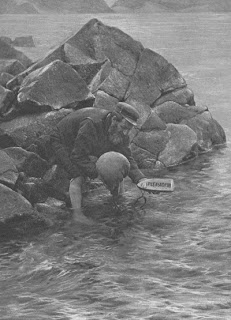
In the past the only way for the inhabitants of St Kilda to contact the wider world was for them to light a bonfire and hope a passing ship would see it. They would sometimes also use the St Kildian ‘mailboat’: this was a message-in-a-bottle affair, with an inflated sheep's bladder attached, that was dropped in the ocean when the winds were coming from the northwest. Amazingly, two-thirds of their missives were eventually washed up and found on the shores of Scotland (or of Scandinavia when less lucky).

· Its population

The population of St Kilda has always been small. In 1758 there was a population of 88, and that was recorded as an improvement. In an 1841 census (the first time Britain remembered that it had some distant islanders in its kingdom who also ought to be tallied) there were 96 people, coming from only eight family names: Mackinnon, Macdonald, MacQueen, MacLeod, Macrimmon, Morrison, Gillies and Ferguson.

The village

The village street, 1886
A new village was built in Village Bay in the 1860s to replace the medieval one. Village Bay, which is on the east coast of Hirta, is the most sheltered part of the island as Dùn protects it from southeasterly winds. Since the island has no trees for wood, the cottages were made from stone and thatch. There are only a couple dozen cottages along the street – you would literally come to know all the people whom you were likely ever to know!

· Its unique society

St Kilda, owing to its isolation, essentially became an island republic, though officially it was under the lairdship of its Scottish landowner. It developed a type of socialism. Resources and food were shared amongst the community. There was no private property and inhabitants bartered for what they needed.

There was no local government. A ‘parliament’ of all the able-bodied men would meet every morning after prayers on the grass in front of the village to decide on the day’s work activities. The downside of this was that when a poor decision was made (one, for example, that would lead to the loss of a crop), the entire community would suffer the consequences and there was no backup to be had.

· The privations

Infant mortality was always high. A staggering 80% of the babies born between 1830 and 1834 died from tetanus as there was no proper midwifery. And medical help was literally an ocean away.

There was no electricity or running water on the island.

· Winters

The village in winter
Winters were incredibly long and bitter. There were frequently food shortages. The cattle would occupy one end of the house. The men worked in their sheds while the women sewed. The importance of community and mental strength really came into play at this time of the year. The St Kildians fought against depression with music and dance, which they loved, and they would also tell humorous story poetry.

· Religion

It isn’t known when and how Christianity first came to St Kilda, though some suggest anchorites took the religion there. One stone cross that can be found at house no. 16 in the village is thought to possibly date from as far back as the C7th. But until the arrival of missionaries in the eighteenth and nineteenth centuries, the St Kildians’ religion was in many ways druidic, and druidic altars have been found on the islands.

Church of Scotland ministers became a permanent feature on St Kilda from the beginning of the C19th. They instigated the building of a church and manse, started a school (thereby introducing the islanders to formal education) and helped improve agriculture. Observance of the Sabbath was enforced.

· Visitors and tourists

In the C17th the only way of reaching St Kilda was in a longboat, which meant days and nights on the open, rough sea. While the occasional wayward ship would shelter in Village Bay, and the odd explorer would also visit, the inhabitants’ interaction with outsiders was sporadic.

In the late nineteenth century, however, Victorian steamcruisers started to take in St Kilda as part of their itinerary. This introduced the islanders to monetary trade, as they could sell visitors tweeds and bird eggs. It brought the St Kildians some new comforts, but their pride was hurt as they were made to feel curiosities. Their way of life was also increasingly undermined as their previous isolation had forced them to work hard at cultivating a self-sufficient society.

It was missionaries and tourists who prompted many St Kildians to learn English.

· The effects of WW1

The St Kildians lived in blissful ignorance of the rest of the world’s troubles and for centuries were unaffected by the turmoil of European politics and warfare. No St Kildian ever fought in a war. Furthermore, there were no guns on the island, no prisons, and no serious crimes were ever recorded.

WW1 increased the islanders’ contact with the outside world. The Royal Navy installed a signal station and guns on Hirta. No fighting actually took place on the island, though a German submarine did shell the station. But for the first time ever the St Kildians had regular contact with the mainland. This chipped away at their self-reliance.

· Its evacuation

Life on St Kilda was not always as difficult as it became in the last few centuries. The islanders were reportedly flourishing in the C17th, having a high population and plenty of food. But visiting ships in the C18th introduced previously unknown diseases to the St Kildians. In 1851 thirty-six St Kildians emigrated to Australia, and the community never really recovered from this sizeable loss.

In the twentieth century circumstances conspired to wear down those who remained. There was an outbreak of influenza in 1913. Many of the young men left the island after WW1 and the population went from 73 in 1920 to 37 in 1928. The number of able-bodied men was not sufficient to enable the small community to weather the endless winters. Then, in 1929, a young woman died from appendicitis.

So in 1930 the entire community of 36 people was evacuated off the island, in response to their request for the British government to transport them to the mainland. (Many of the men subsequently became involved in forestry, because although they had lived where there are no trees, their rock climbing skills made them excellent tree climbers.) St Kilda was left to the birds and sheep.

· After 1930

Three plane wrecks from WW2 can be found on the islands. These occurred at a time when the islands were completely abandoned. There were no survivors.

The village street in 1988
People returned to St Kilda in 1957 when a small army complex was built in Village Bay as part of the Hebrides missile tracking system. Military personnel live on Hirta year-round. Scientists also now stay on the islands so as to research the feral Soay sheep population. Volunteer work parties frequently make summer trips to help renovate and preserve the buildings of the village.

· Its World Heritage status

In 1931, the Marquess of Bute, an avid ornithologist, bought the islands and then conferred them on the National Trust for Scotland in 1957. St Kilda was made into a UNESCO World Heritage Site in 1986 because of its extraordinary landscape. In 2004 this status was extended to include the islands’ surrounding marine life. The following year St Kilda was chosen as one of a few dozen sites around the world to be honoured as a dual status World Heritage Site, noted for its geological as well as cultural significance.
______________________________________________

Footnotes:
* Baxter, C. and Crumley, J. (1988). St Kilda: A portrait of Britian’s remotest island landscape, 7.
^ Go to http://www.flickr.com/photos/39617394@N00/624170764 to see my favourite photo of gannets in flight over Boreray.

Photo credits:
- Soay. (Olaf1950, public domain.)
- Saint Kilda archipelago topographic map. (Eric Gaba – Wikimedia Commons user: Sting. March 2009. Used under GNU FDL.)
- Stac an Armin and Boreray. (Stephen Hodges. Used under the Creative Commons Attribution-Share Alike 2.0 Generic license.)
- Fulmar hunting. (Richard Kearton, public domain.)
- Cleit above Village Bay on Hirta. (Bob Jones. Taken 2006. Used under the Creative Commons Attribution-Share Alike 2.0 Generic license.)
- The 'mailboat', 1898. (Richard Kearton, public domain.)
- St Kildans sitting on the village street, 1886. (Unknown, public domain. Property of the National Trust for Scotland.)
- Hirta village in the snow. (Owen Jones. Taken Feb 2001. Used under the Creative Commons Attribution-Share Alike 2.0 Generic license. http://www.flickr.com/photos/jonesor/.)
- The inhabitants, 1898. (Richard Kearton, public domain.)
- The village street, 11 May 1988. (Des Colhoun. Used under the Creative Commons Attribution-Share Alike 2.0 Generic license. http://en.wikipedia.org/wiki/File:The_Street.jpg.)

Thursday, March 25, 2010

The history behind Easter traditions


Lent, Mardi Gras, Ash Wednesday and Maundy Thursday: these are all terms heard a great deal at this time of year. But what exactly do they mean and where do they come from? The special dates and traditions that are upheld as the days draw near to Easter Sunday have a long and intriguing history in Christian practice.

Most of the West’s time-honoured Easter traditions began in Europe, where Lent coincides with the beginning of spring. The words ‘Lent’ and ‘Easter’ are both derived from old English words: ‘Lent’ is an ancient Anglo-Saxon word that means ‘springtime’, and ‘Easter’ comes from the word Eastre or Eostre, which was the name given to the Goddess of Spring, who represented dawn and new light. As so frequently occurred, early church leaders adapted pagan traditions to fit in with the newly introduced Christianity. The already existing focus on the new light of the spring season thus came to refer to the spiritual dawn or new light Christ brought into people’s lives when he defeated death by rising from the grave.

Lent, which is forty days long, begins on Ash Wednesday, a day so named because in the Old Testament men and women covered themselves with ash during times of sorrow. The church adopted this practice during Lent as a sign for sorrow over one’s sins. Ash Wednesday thus heralds the start of a period in which men and women traditionally adopt a sombre and prayerful attitude, focusing on self-discipline, self-reflection and partial fasting (and also penance for Catholics). Lent then ends on Easter Sunday.

By the Middle Ages, food restrictions during Lent were a matter of enforcement; no meat, dairy or eggs were allowed, these being thought of as foods that give one pleasure. So the days and weeks leading up to Lent thus became a time when all the rich and fatty foodstuffs in one’s parlour were to be used up before Lenten fasting begins. These days became days of ‘carnival’, a word derived from the Latin for ‘a farewell to meat’. Shrove Tuesday – the time when Christians ‘shrive’ themselves, or confess their sins – is the last day of carnival, and it thus also became a day known to many as Fat Tuesday (or Mardi Gras in French).

In some areas Fat Tuesday it is also known as Pancake Tuesday. In the English town of Olney women have, for the past five hundred years, met in the town square with hot frying pans and raced one another to the church while flipping pancakes in the air.

In the first century, Lent was only forty hours long, Christians observing the actual period during which Jesus lay dead in the tomb. Lent was then broken at 3am on Easter morning with the church meeting to celebrate. I remember as a young girl in the Anglican Church how we would meet in the dark at 5:30am for an early Easter Sunday service. We would light candles and hold vigil for the ‘light’ of Easter Day. When first light came we would all wildly shake and rattle homemade instruments to celebrate Jesus’ rising from the dead.

The hot cross bun, also popular in the West, was supposedly first baked by an English monk who was moved to compassion when he saw poor, hungry families on the street during Lent. He baked the buns, added a symbolic white cross on the top, and gave it to them, hoping they would not be robbed of the joy of Easter.

The Sunday before Easter Sunday is Palm Sunday, when Jesus entered Jerusalem on a donkey and men and women waved palm fronds at him and also laid them on the ground so as to provide him with a softer path.

The last week of Lent is Holy Week. The first notable day during Holy Week is Maundy Thursday. It was on Maundy Thursday that Jesus sat around the dining table with his disciples and gave them the commandment to “love one another as I have loved you”. The Latin word mandatum, from which comes ‘Maundy’, means ‘commandment’.

The following day, Good Friday, Jesus was crucified. It is a “Good” Friday because he took on himself the punishment that mankind deserves, but it is also known as Black Friday in many parts of Europe because Christians remember the darkness and suffering Christ endured on their behalf.

The day for observing Easter is different every year because in the fourth century church leaders agreed that Easter Day would be every first Sunday after the full moon that follows the Spring Equinox (20 or 21 March).

In the Middle Ages, eggs were given to children and servants on Easter Day, a lovely gift because dairy foods had been denied everyone during Lent. The egg is also an obvious symbol of birth and life. It predates Jesus’ crucifixion as a sign of new life, but early Christians adapted its meaning so that the eggshell represents Christ’s tomb and the emergence of the bird represents his victorious breakout from the tomb. Today the symbolism of the egg remains, but the egg has been turned into a chocolate egg.

Easter Sunday is all about celebration, with Christians rejoicing over Jesus’ resurrection from death. Early Christians used to hold feasts, dance and sing, and play practical jokes on one another, celebrating the ‘final joke’ that Jesus played on the devil when he rose from the grave.